Record, near-record lows expected across area through Christmas
By DON FLETCHER
News Staff Writer
People often joke about Alabama’s rapidly changing weather patterns and its relatively short period of winter weather. What’s headed our way later this week is anything but a joke.
An arctic cold front that is expected to move across Atmore and the surrounding area Thursday night will bring subfreezing temperatures that will challenge the National Weather Service’s records and keep Lower Alabama in a deep freeze through Christmas.
Escambia County Emergency Management Agency Director David Adams reported that temperatures by Friday morning will be in the teens and 20s across much of the state’s interior, with upper 20s and low 30s near the coast.
Stiff winds out of the northwest will produce wind chill values in the single digits across northern portions of the immediate area. High temperatures on Friday will likely stay near, or just below, freezing for most areas northwest of I-65, with wind chills in the teens and 20s for most of the area.
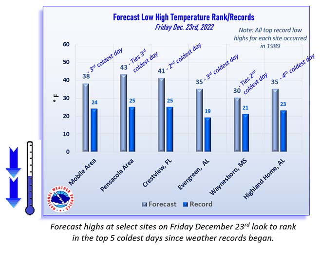
For many locations on Friday the currently forecasted highs for that date (the 23rd), will be among the five coldest daytime maximum temperatures ever recorded on that date.
The area’s coldest temperatures are expected Friday night, with lows ranging between 10-20 degrees north of I-10 and low- to mid-20s in coastal areas. Wind chill values Friday night into Saturday morning will likely be in the single digits in areas away from the coast.
Similar overnight temperatures are also expected Saturday and Sunday nights, but a few degrees warmer each night. Daytime highs will slowly moderate as well, with highs on Saturday mainly in the 30s (40s along the coast) and by Sunday nights warming into the mid-40s to lower 50s across the area.
Local public safety officials say they have weather-guarded their buildings and vehicles, but they can do little but wait and see what effect the frigid weather will have on the city and surrounding area.
“There’s not much we can do right now,” said Atmore Streets and Sanitation Department Director Calvin Grace. “We’ve got sand and stuff ready if there’s ice on the roads.”
Grace added that trash and garbage collections will continue as scheduled throughout the week, including Friday and Monday, when most other city offices will be closed.
Police Chief Chuck Brooks said the possibility of ice on city streets and area roadways should force motorists to use caution.
“We’re most likely going to get some ice on our streets and roads,” he said. “People need to slow down and be mindful that friction between a tire and the roadway is limited. Take your time.”
Ron Peebles, the city’s fire chief, reminded locals of the most potentially damaging or destructive effect of the bitter cold, the use of space heaters.
“If we have a problem, that’s probably where it will be,” Peebles said. “Watch those space heaters close; don’t put blankets or curtains anywhere within three feet of them and unplug them if you leave home.
“I don’t know how long it’s been since we’ve had weather this cold, so we’re just going to sit back and hope for the best, hope everybody does well. We’ll be here if we’re needed.”
NEWS forecasters say some areas north of Highway 84 will likely fall below freezing Thursday night or Friday morning and will not rise above freezing again until Sunday afternoon. Gale watches and warnings are expected across the marine area as well.