Pine Barren Watershed project would help ease downtown flooding
By DON FLETCHER
News Staff Writer
A plan to use federal money to alleviate much of the flooding that plagues downtown Atmore, a plan that was first approved nearly 20 years ago, is apparently back on the table.
Officials of the United States Department of Agriculture’s Natural Resources and Conservation Services (NRCS) are expected to meet this week with officials of NRCS Alabama to discuss the future of a proposed $19 million project designed to mitigate the flooding that is rampant in the city, especially its southeastern sector.
That mitigation will come through drainage improvements to be made in the Pine Barren Creek Watershed, which includes Atmore and much of northwestern Florida.
Mayor Jim Staff said the city is ready to move, if and when the project gains official approval.
“We’re ahead of the game,” Staff said. “We’ve got the Goodwyn Mills Cawood (engineering) study that was done in 2008, and we’ve also got one that was done by Civil Southeast late last year or early this year. We’ve got two studies we can back up on that are already done, so we’re a little bit ahead of them right there.”
City Codes Enforcement Officer Greg Vaughn said last week he was told by an official of NRCS Alabama that representatives of the federal office and the state office are scheduled to meet this week to go over the watershed plan and see if it is still feasible.
“The national office will review the watershed plan; we’ll know something more after that meeting,” Vaughn said. “What will come out of that review is whether the current watershed plan, a very vague plan for what’s to occur in Atmore — to extend ditches and maybe storm sewers in Atmore to tie into the main channels — is feasible or if the current plan needs to be updated, revised or reconfirmed.
“That will determine how they move forward.”
The project was first approved in 2008 as part of the federal Watershed Protection and Flood Prevention Act.
City officials were informed at least five years earlier of the funding proposal, and two public hearings were held — one in 2003 and one in 2007. Environmental impact studies were conducted, two interagency meetings were held to gather input from local, state, and federal government agencies, and it appeared the project was on the fast track to implementation.
Then it was apparently put on a back burner and forgotten until November 2021, when the Infrastructure Investment and Jobs Act (also known as the Bipartisan Infrastructure Law) was passed by Congress and signed into law by President Joseph Biden.
The new law authorized the spending of $55 billion to “rebuild America’s roads, bridges and rails; expand access to clean drinking water; ensure every American has access to high-speed internet; tackle the climate crisis; advance environmental justice and invest in communities that have too often been left behind.”
The primary goal of the Pine Barren Watershed project is to relieve flooding problems, especially in Atmore, while maintaining the quality of water in Pine Barren Creek.
The creek runs behind the former Escambia County Middle School building on Martin Luther King Avenue, and under U.S. 31, McRae Street and Old Bratt Road as it winds into Florida.
It breaks off from the Alabama River in Wilcox County, crosses into Florida just south of Atmore and eventually becomes part of the Escambia River that empties into Pensacola Bay.
Widespread flooding is common in Atmore, especially during and after heavy rains, although the city partnered several years ago with Poarch Band of Creek Indians to add drainage pipes beneath Montgomery Street that officials thought might solve the problem.
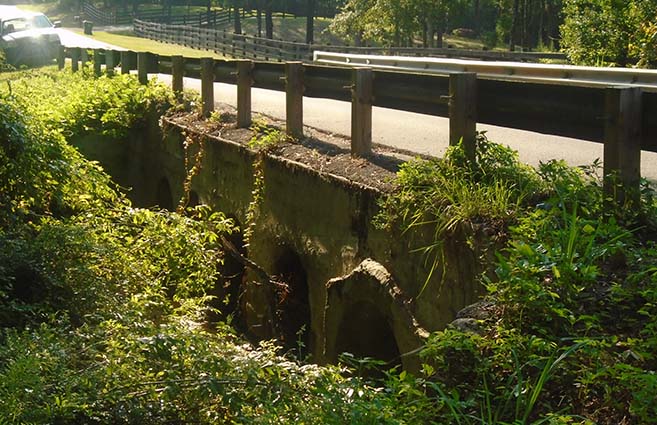
Most of the drainage conduits are at least partially clogged by debris, especially those under the bridge that spans the creek segment under Greenland Road, just across the Florida line. That slows the drainage of rainwater and causes it to back up into Atmore.
The major components of the flood alleviation plan are to (a) deepen the existing channel in the creek’s headwaters; (b) install a grade stabilization structure; (c) modify an existing weir (a low dam built across a river to raise water upstream or regulate the flow of water) and (d) install reinforced concrete laterals (drainage pipes) within the city’s residential areas that are prone to flooding.
Vaughn pointed out that the wheels of government, especially at the federal level, turn slowly. He cautioned that local officials and residents shouldn’t get overly excited over the plan, at least not yet.
“This is in the study phases,” he said. “It’s not people getting on an excavator and digging; that’s not where we are right now. This is in the engineering study-type phases, when they start doing studies, hiring engineers and spending money.”
The mayor said he would try to remain optimistic that a solution is in the works, although he speculated that the cost of engineers and consultants would eat away at the $19 million award.
“We’re going to write up a deposit slip; we’re just not going to fill it out yet,” he joked.