David Adams, EMA director for Escambia County (Ala.) reported Friday morning the latest forecasts from the National Weather Service on the potential for severe weather in the area Saturday and Saturday night:
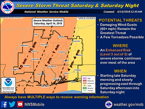
The NWS reports that a well-organized squall line still looks on track to bring an enhanced potential of severe weather along with heavy rainfall to our local area Saturday and Saturday night
Severe Weather Impacts:
There still remains some uncertainty on the timing and exact location of the severe weather threat, but we are still looking for the squall line to progress across our southeast Mississippi and southwest Alabama counties either late Saturday morning or Saturday afternoon, before making an eastward advancement across the remainder of the region from late Saturday afternoon through Saturday night.
Emergency officials will likely also monitor for the development of discrete rotating cells ahead of the line. There will be sufficient instability and shear for a damaging winds threat and also a few brief tornadoes.
The Storm Prediction Center (SPC) has continued an Enhanced Risk of severe storms over most of our area Saturday (there was a reduction to a Slight Risk over our far eastern areas, but please do not let your guard down). Given the uncertainty, the timing of the severe threat has been kept pretty close to what was announced on Thursday.
It generally looks like the best severe threat will be from the late morning through the evening hours, with the severe threat gradually diminishing after midnight. Officials will try to narrow down these time ranges as the anticipated weather event draws closer and they become more confident with their data.
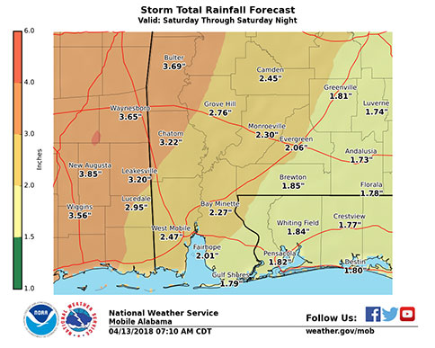
Heavy Rainfall/Flooding Impacts:
Heavy rainfall remains possible as the squall line slowly makes its way across our region. An elevated threat of flooding continues for areas generally along and to the west of a Greenville, Ala. to Pensacola, Fla. line, where 2 to 4 inches of rain, with locally higher amounts over 5 inches, will be possible.
Isolated instances of flash flooding remain possible in the Elevated threat area. EMA and NWS will continue to monitor the latest data coming in today to determine if a Flash Flood Watch will become necessary. A more limited flooding threat will exist east of this line, where 1 to 2 inches of rain with locally higher amounts is currently forecast.
Rip Current and High Surf Impacts:
National weather forecasters also mentioned that there is a High Risk of rip currents along our local beaches starting this evening and continuing through Sunday night and are also monitoring the potential for high surf (over 5 feet) Saturday and Saturday night.