By DON FLETCHER
News Staff Writer
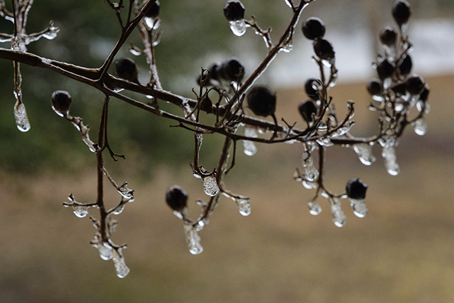
Residents of Atmore and most everywhere else in the state woke up Tuesday morning (January 16) to frozen rain puddles, ice on vehicle windshields and windows, and even a light dusting of snow as an Arctic air mass that moved into the state Monday night finally reached into the area.
Temperatures in the mid-20s prevailed Tuesday morning, and things are projected to get worse as the frigid air mass lingers in the area for the remainder of the week.
Thermometer readings in the mid-teens are forecast for Wednesday morning (January 17), with 15 mph north-to-northwest winds that could bring single-digit wind chills to most of Southwest Alabama, including Atmore. If a 24-percent chance of overnight rain develops, it could make things even bleaker.
Gov. Kay Ivey issued a state of emergency for 25 counties in the state’s northern sector.
“We are anticipating unusually cold temperatures in Alabama this week, so I am urging everyone to be prepared, take caution traveling and stay weather aware,” the governor said.
The state of emergency in the northern and western counties went into effect at 2 p.m. (CST) Sunday, January 14, and remains in effect through Sunday.
Locally, Wednesday’s daytime high is expected to reach only into the mid-40s, and the rest of the week isn’t looking much warmer.
Thursday’s projected high of 59 degrees and a low of 43 into Friday is projected to be this week’s warmest period. Daytime temperatures aren’t expected to top 50 degrees but once during the week’s other days, with overnight lows in the 20s forecast for Wednesday, Friday, Saturday and Sunday.
Spinks Megginson warned on his Red Zone Weather site that the threat of ice or “black ice” is possible on area streets, roads and bridges. He announced that a Winter Weather Advisory has been issued for Monroe, Clarke, Washington, northern Mobile and northern Baldwin counties to account for this possibility, although such a situation could arise locally, also.
“Regardless of if ice accumulation happens, black ice will be a concern on local roadways in these counties and zones, and beyond,” Megginson said, noting that black ice got its name from the fact the ice is visually transparent, allowing the black road below to be seen through it.
According to the National Weather Service website, black ice “looks like pavement, so if temperatures are near freezing, drive slowly like you’re on ice. Leave plenty of room between you and the vehicle ahead of you and avoid sudden braking or sudden acceleration.”
After an expected low of 29 Monday morning (January 22), daytime highs are expected to slowly climb from Monday’s 57 to Tuesday’s 64, to 70 on Wednesday and Thursday before returning to the mid-60s on Friday and Saturday, with lows only reaching into the 40-degree range.
The warmer weather is expected to bring a steady diet of rain. Forecasters at The Weather Channel have predicted that chances of showers or scattered thunderstorms would be in the 40-percent to 60-percent range each day, Tuesday through Saturday (January 23-27).
Residents are urged to take precautions during the cold spell:
*Bundle up and wear several layers of clothing.
*Cover exposed outdoor pipes and faucets, leave water dripping in sinks, tubs, etc.
*Bring sensitive plants and pets inside until the weather warms up.
Cold weather also raises the possibility of house fires, and residents are urged to follow the following steps:
*Make sure clothing and other flammable materials are kept at least three feet from all sources of heat, especially space heaters and fireplaces.
*Use a screen on fireplaces to make sure no embers pop out and land on floors or flammable materials.
*Turn off all space heaters when leaving home or when they are not in use.
*Use caution when a stove is being used to help heat your home. Make sure the stovetop is clear of any food, grease or other flammable materials.
[…] Story continues […]