Thankfully, only minor damage here
By DON FLETCHER
News Staff Writer
Most people not schooled in meteorology had probably never heard of a derecho when local skies began to darken last Thursday, June 28, and most probably still don’t know exactly what a derecho is.
But residents of Atmore and the surrounding area got a brief glimpse that day of the power and fury such a weather phenomenon can bring.
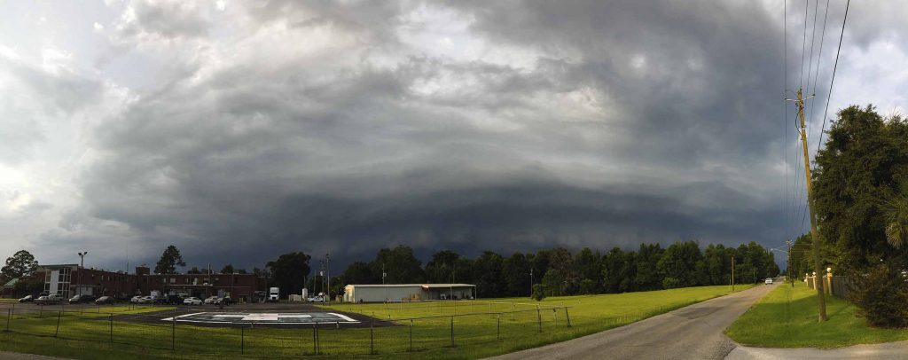
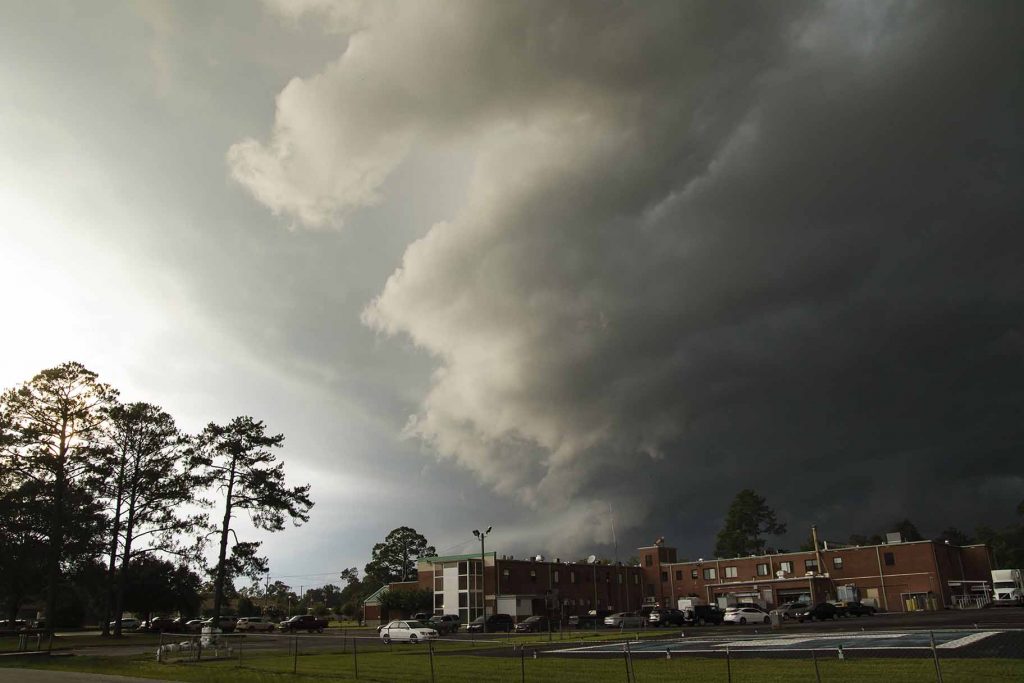
According to Merriam Webster, a derecho is “a large, fast-moving complex of thunderstorms with powerful straight-line winds that cause widespread destruction.” Derechos are basically bow-shaped bands of severe winds that come barreling across the landscape at speeds typically 50 mph or greater with an ominous-looking shelf cloud leading the way.
According to the National Weather Service, three such “intense squall lines” erupted across the country on June 28, making that day the most weather-active of the year so far. The trio of derechos included one that swept from middle and eastern Tennessee, across Alabama and into northern Florida before it moved off to sea.
Weather.com reported that the furious windstorm carved a swath approximately 380 miles along its major axis, toppling a tree onto a car and killing a Lineville man as it moved through the state. NWS offices from eastern Montana to the Gulf Coast received “just under 500 reports of thunderstorms with high winds or wind damage” on June 28.
The boiling mass of meteorological mayhem stormed into Escambia County around 2:40 p.m. and raced into the fringes of Atmore just minutes later.
The tightly packed mass of tempests brought winds estimated at 55 mph and sent sand, rocks and gravel flying ahead of them. Tops and limbs were sheared from trees along Alabama 21 and several city streets. One reportedly knocked out power for a lengthy period across an area that stretched from Nashville Avenue (U.S. 31) to the neighborhoods southwest of Tom Byrne Park.
City pools at Tom Byrne and Houston Avery parks, as well as Atmore Community Splash Pad, were evacuated just moments before the system began dumping buckets of rain into its winds, gaining strength as the precipitation was sucked back into the pack of gray-black clouds and recycled.
Then, suddenly, it was over.
Wet streets and small pools of water in residential yards, along with the fallen trees and resultant power outage, turned out to be the only tangible proof the wild weather had ever been here.
“It left out of here about as quick as it came in,” noted Lt. John Stallworth of the Atmore Police Department. “I didn’t get any calls out, and we didn’t have any major accidents.”
Atmore Fire Department reports show that all on-duty and off-duty firefighters were called in as a precautionary measure, but the weather crisis ended before most could get far from their homes.
“We had a few trees down,” said AFD Capt. Daniel Love. “That and the power outage, which was actually caused by a tree falling into a transformer, was about all we got from it.”
That wasn’t the case all over the county and state, though. Alabama Power reported that 98,000 customers were without electricity by the time the system took its leave of the state. The straight-line winds reportedly toppled trees — some of them onto houses and cars — as it moved through Brewton, where it also tore roofs off some buildings and blew down several structures.
Madison County sustained widespread tree damage, with several falling on homes, when winds estimated by the National Weather Service as “up to 100 mph” — the equivalent of a Category 2 hurricane — tore through an area near Gurley.
Recreational vehicles were blown over, barn roofs were ripped off and windows were blown out in White Plains; bleachers at Clements High School, near Rogersville, sustained heavy damage.
The first derecho of 2018, while terrifying enough, didn’t compare to the one that struck on June 29, 2012. That one traveled 450 miles in six hours as it sped from the Midwest to the East Coast, leaving millions without power and 22 dead.
A May 8, 2009 storm system was particularly malignant and earned a new classification, “,” as it carved a path of destruction 100 miles wide in Kansas, spawning 18 tornadoes and packing wind gusts of 90- to 100-mph when it hopped the Mississippi River into Illinois.
Jeffrey Dorrity, who said he lives “in the Perdido-Nokomis area,” had taken shelter inside the local Little Caesar’s pizza outlet after flying debris began pelting his car.
“That was some mean-looking clouds,” Dorrity said. “It wasn’t here but a minute, just sort of here and gone. We didn’t get the bad weather (that) I bet they got in a lot of other places. I bet it would have got real ugly around here if that thing had stayed around a few more minutes.”into the fringes of Atmore just minutes later.
The tightly packed mass of tempests brought winds estimated at 55 mph and sent sand, rocks and gravel flying ahead of them. Tops and limbs were sheared from trees along Alabama 21 and several city streets. One reportedly knocked out power for a lengthy period across an area that stretched from Nashville Avenue (U.S. 31) to the neighborhoods southwest of Tom Byrne Park.
City pools at Tom Byrne and Houston Avery parks, as well as Atmore Community Splash Pad, were evacuated just moments before the system began dumping buckets of rain into its winds, gaining strength as the precipitation was sucked back into the pack of gray-black clouds and recycled.
Then, suddenly, it was over.
Wet streets and small pools of water in residential yards, along with the fallen trees and resultant power outage, turned out to be the only tangible proof the wild weather had ever been here.
“It left out of here about as quick as it came in,” noted Lt. John Stallworth of the Atmore Police Department. “I didn’t get any calls out, and we didn’t have any major accidents.”
Atmore Fire Department reports show that all on-duty and off-duty firefighters were called in as a precautionary measure, but the weather crisis ended before most could get far from their homes.
“We had a few trees down,” said AFD Capt. Daniel Love. “That and the power outage, which was actually caused by a tree falling into a transformer, was about all we got from it.”
That wasn’t the case all over the county and state, though. Alabama Power reported that 98,000 customers were without electricity by the time the system took its leave of the state. The straight-line winds reportedly toppled trees — some of them onto houses and cars — as it moved through Brewton, where it also tore roofs off some buildings and blew down several structures.
Madison County sustained widespread tree damage, with several falling on homes, when winds estimated by the National Weather Service as “up to 100 mph” — the equivalent of a Category 2 hurricane — tore through an area near Gurley.
Recreational vehicles were blown over, barn roofs were ripped off and windows were blown out in White Plains; bleachers at Clements High School, near Rogersville, sustained heavy damage.
The first derecho of 2018, while terrifying enough, didn’t compare to the one that struck on June 29, 2012. That one traveled 450 miles in six hours as it sped from the Midwest to the East Coast, leaving millions without power and 22 dead.
A May 8, 2009 storm system was particularly malignant and earned a new classification, “,” as it carved a path of destruction 100 miles wide in Kansas, spawning 18 tornadoes and packing wind gusts of 90- to 100-mph when it hopped the Mississippi River into Illinois.
Jeffrey Dorrity, who said he lives “in the Perdido-Nokomis area,” had taken shelter inside the local Little Caesar’s pizza outlet after flying debris began pelting his car.
“That was some mean-looking clouds,” Dorrity said. “It wasn’t here but a minute, just sort of here and gone. We didn’t get the bad weather (that) I bet they got in a lot of other places. I bet it would have got real ugly around here if that thing had stayed around a few more minutes.”

News photos by Ditto Gorme
